AgriSat: Precise Agro-Ecological Zoning for Future-Ready Farming

The Agricultural Challenge & Farmer Needs
Modern agricultural practice faces critical hurdles in optimizing land use and maximizing yield due to reliance on outdated or cumbersome data methods. Existing methods for Agro-Ecological Zoning are currently challenged by being notoriously slow, characterized by high costs, and often complex to execute effectively. To succeed in a competitive environment, farmers require a solution that is fundamentally different. Their explicit needs are for tools that are fast, deliver accurate results, and are both simple to implement and affordable. This gap between the available methods and the practical needs of the farmer represents a significant opportunity for innovation.
AgriSat Solution: Integrated Zoning and Q&A Tool
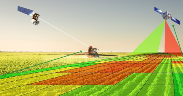
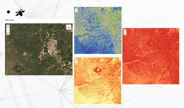
AgriSat directly addresses these challenges by offering an innovative platform that combines Agro-Ecological Zoning with an Integrated Question-and-Answer tool. The platform provides localized, optimal guidance for key agricultural decisions, visualizing zones on a map based on multiple critical factors:
- Plant Suitability (identifying the best crops for the area)
- Ecology/Soil Type (understanding the environmental fit)
- Irrigation Needs (determining optimal water usage)
- Productivity Forecasts (predicting potential yield)
Market Potential & Competitive Edge
The potential market for AgriSat is vast, targeting a base of approximately 700,000 farmers, with an estimated 640,000 (91.4%) identified as active potential users. In the competitive landscape, AgriSat positions itself as the Most Suitable (Ideal) choice by excelling in the critical metrics that matter most to farmers: it is fast, cheap, simple to use, and focuses on local application.
Sustainable Development Goal (SDG) Alignment
AgriSat’s mission to optimize land use and increase agricultural efficiency is strongly aligned with core United Nations Sustainable Development Goals (SDGs), focusing on environmental and food security pillars.
- SDG 2: Zero Hunger: AgriSat directly supports the goal of achieving food security by utilizing precise agro-ecological data to improve crop selection, irrigation efficiency, and overall productivity forecasts. This leads to increased sustainable food production and better resource utilization, which is essential for combating hunger.
- SDG 12: Responsible Consumption and Production: By providing guidance on irrigation needs and optimal plant matching, AgriSat promotes resource efficiency in agricultural production. This smarter approach reduces the excessive use of water and other inputs, contributing to responsible management of natural resources.
- SDG 15: Life on Land: The focus on ecology and proper land management is integral to the Agro-Ecological Zoning process. By ensuring that crops are suited to the local environment and soil, AgriSat helps prevent land degradation and supports the sustainable use of terrestrial ecosystems, which is key to protecting biodiversity and maintaining healthy land.
The development of the AgriSat platform was deeply rooted in the technical excellence and guidance provided by the esteemed faculty and mentors of the Faculty of Information and Computer Technologies. Their collective expertise was indispensable in crafting the platform's core functionalities, particularly in the implementation of advanced data processing algorithms, GIS-based visualization for Agro-Ecological Zoning, and the creation of the Integrated Question-and-Answer tool. This foundational technological support ensured AgriSat is a fast, accurate, and simple-to-use solution for optimizing land use and maximizing crop yields for farmers.